Jamming erases it.
Interference raises the noise around GNSS bands until satellite signals can’t be tracked. The vehicle keeps moving. Its position solution doesn’t.
Software-defined GNSS · Resilient PNT
The PNT landscape
Every autonomous system runs on one assumption: it knows where it is. That knowledge is a single point — and it can be attacked without touching the vehicle.
Interference raises the noise around GNSS bands until satellite signals can’t be tracked. The vehicle keeps moving. Its position solution doesn’t.
Counterfeit signals that look legitimate pull the reported position somewhere the vehicle isn’t.
Buildings and terrain block and reflect signals. Multipath and obstruction blur the solution.
Traditional GNSS receivers tie critical signal processing to specialized hardware, making upgrades slow as threats evolve.
We move that processing into software, allowing new capabilities and threat mitigations to be deployed as operating environments evolve.
Software-defined GNSS
Software-defined GNSS receivers can be updated as threats change, so positioning stays accurate when jamming, spoofing, and denial show up in the field.
Capabilities are delivered as software. Push an update to see what changes — and what doesn’t.
Maintains positioning performance under jamming, spoofing, and interference across dynamic, real-world platforms.
GNSS signal processing runs in software on edge compute already deployed on your platform, minimizing additional hardware.
Deploy new positioning capabilities and threat mitigations through software updates, without redesigning receiver hardware.
GNSS signal processing runs in software on edge compute already deployed on your platform, minimizing additional hardware. Leo200-S hardware: 14 g, 1.39 W while streaming.
Leo200
Leo200 is a software-defined GNSS receiver that runs on commodity compute, with capabilities that improve through software updates. Leo200-S and Leo200-D run the same PpRx receiver software — the difference is the included RF front end.

Software-defined GNSS receiver with single-antenna turnkey RF front-end.
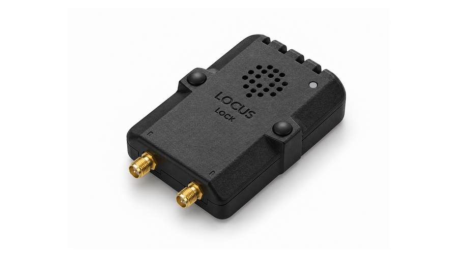
Dual-antenna carrier-phase differential GNSS with integrated IMU for precise heading and 3D attitude.
PpRx GNSS SDR software SDK. Maximum configurability + existing RF hardware stacks.
PpRx · the software-defined GNSS engine
PpRx accepts digitized GNSS RF samples and performs acquisition, tracking, signal processing, navigation, estimation, and threat-mitigation functions in software on general-purpose compute — the core of every Leo200 configuration.
| PpRx only | PpRx + GUI (eval kit) | |
|---|---|---|
| CPU | 64-bit, 1+ core, 1+ GHz* | 64-bit, 4+ cores, 1+ GHz |
| RAM | 100 MB* | 2 GB |
| Storage | 1 GB* | 5 GB |
| Interface | CLI / programmatic | GUI + CLI |
* Configuration-dependent: varies with enabled signals, channel count, processing configuration, and RF data rates.
CLI and programmatic interfaces; custom middleware and interfaces available through Locus Lock.
Real-world validation
Four published field evaluations: jamming, spoofing, high-dynamic flight, and urban multipath. These are the test conditions and results exactly as Locus Lock reports them, with raw data where it’s available.
Tested on a UAS in a contested electromagnetic environment with high-power, multi-frequency GNSS jamming.
Maintained uninterrupted positioning by automatically adapting to changing interference conditions.
Test conditions: Tested on a UAS in a contested electromagnetic environment with high-power, multi-frequency GNSS jamming.
Result: Maintained uninterrupted positioning by automatically adapting to changing interference conditions.
Test conditions: Tested on a ground vehicle at high latitudes during an active GPS spoofing attack.
Result: Maintained accurate positioning by identifying and rejecting spoofed satellite signals.
Test conditions: Evaluated on an aerial delivery (air drop) platform during a high-speed mission with aggressive flight dynamics.
Result: Achieved rapid position lock while maintaining reliable navigation throughout the mission.
Test conditions: Evaluated on a ground vehicle in a dense urban environment with severe GNSS multipath and signal obstruction.
Result: Maintained centimeter-level positioning accuracy despite challenging urban conditions using dual-antenna carrier-phase differential GNSS coupled with an IMU.
From eval to production
Start with the evaluation kit and validate it on your platform. Then work with the Locus Lock team on an off-the-shelf or custom production path. Pricing scales with volume, with perpetual licenses and no subscription fees.
Install the software, activate your license, and generate your first position fix using live or recorded GNSS data.
Connect the kit to your application, assess performance in the lab, then field-test on your target hardware.
Work with us to choose a standard or custom integration, scope engineering support, and scale production.
Technical specifications
| Parameter | Leo200-S | Leo200-D |
|---|---|---|
| Physical | ||
| Dimensions (excl. SMA) | 32 × 65 × 10 mm | 56 × 65 × 9 mm |
| Dimensions (incl. SMA) | 32 × 75 × 10 mm | 56 × 75 × 9 mm |
| Weight | 14 g | 22 g |
| Power | ||
| Connected, idle | 0.64 W | 0.79 W |
| Connected, streaming | 1.39 W | 1.62 W |
| Connector · supply | USB 2.0 Type-C · 5 VDC | USB 2.0 Type-C · 5 VDC |
| RF & timing interfaces | ||
| RF front end | RFx-S · single-antenna, quadruple-frequency | RFx-D · dual-antenna, triple-frequency |
| RF connector | 1 × SMA female | 2 × SMA female |
| Antenna bias | 0 V (off) / 3.3 V (on), < 50 mA | 0 V (off) / 3.3 V (on), < 50 mA |
| PPS output | Header pin | Header pin |
| External clock input | — | 1 × MMCX female |
| Data output | Raw RF & IMU data | Raw RF & IMU data |
| Integrated sensors | IMU + magnetometer | IMU + magnetometer |
| Signals | ||
| GPS | L1C/A, L1C, L2C, L5 | L1C/A, L1C, L2C, L5 |
| Galileo | E1b, E1c, E5a, E5b | E1b, E1c, E5a |
| BeiDou | B1C, B2a | B1C, B2a |
| SBAS | L1 | L1 |
| QZSS | L1C/A | L1C/A |
| Other | Emerging commercial LEO PNT constellations | Emerging commercial LEO PNT constellations |
| Positioning accuracy · standalone GNSS, CEP50 | ||
| Static | < 0.3 m H, < 0.6 m V | < 0.3 m H, < 0.6 m V |
| Low speed (< 12 m/s) | < 0.5 m H, < 1.5 m V | < 0.5 m H, < 1.5 m V |
| High speed (> 22 m/s)‡ | < 1.5 m H, < 0.5 m V | < 1.5 m H, < 0.5 m V |
| Ultra-high speed (60–2000 m/s) | < 1.8 m H, < 4.3 m V | < 1.8 m H, < 4.3 m V |
| Accuracy metrics | ||
| Heading | < 2.5° RMS, < 5° p95 | < 1° RMS |
| Velocity‡ | < 0.3 cm/s RMS | < 3 cm/s RMS |
| Time‡ | < 0.5 ns RMS | < 5 ns RMS |
| 1 PPS GPIO | ±0.1 to ±0.25 ppm (undisciplined) | ±0.1 to ±0.25 ppm (undisciplined) |
| Latency · RF chain → PVT via GBX | ||
| 50th percentile | < 6 ms | < 6 ms |
| 99.9th percentile | < 10 ms | < 10 ms |
| Time to first fix | ||
| Cold start | ~30 s | ~30 s |
| Warm start | ~25 s | ~25 s |
| Hot start | ~1 s | ~1 s |
| Minimum C/N0 thresholds | ||
| Acquisition | 35 dB-Hz | 35 dB-Hz |
| Tracking | 20 dB-Hz | 20 dB-Hz |
| Environmental | ||
| Operating temperature | −20 °C to +70 °C | −20 °C to +70 °C |
| Storage temperature | −40 °C to +85 °C | −40 °C to +85 °C |
| Operating humidity | 5–95 % RH, non-condensing | 5–95 % RH, non-condensing |
| Vibration | 7.7 G RMS [MIL-STD-810H] | 7.7 G RMS [MIL-STD-810H] |
| Shock, operational / survival | 40 G / 75 G [MIL-STD-810H] | 40 G / 75 G [MIL-STD-810H] |
‡ Concept review: these values differ between the product page and the Oct 2026 data sheets, or read as a likely typo. Data sheet values shown. Confirm before launch.
Buy · evaluate
Test performance against your mission requirements before scaling production. Order the evaluation kit online and start on your own platform.
Credibility
Leo200 builds on technology tested against jamming, spoofing, and degraded signals through U.S. DoD programs and operational deployments. Designed, built, and assembled in the United States.
Software-defined GNSS receiver platform, initially available as an evaluation kit.
Announcement ↗Cooperative Research and Development Agreement to advance testing and evaluation of Locus Lock’s software-defined GNSS receiver technology.
Announcement ↗Teamed to deliver software-defined precise PNT capabilities for the U.S. Army.
Announcement ↗Locus Lock’s LEO100 GNSS-SDR platform added to the DIU Blue UAS Framework Cleared List.
Announcement ↗Partnership to develop a software-defined GNSS receiver for Xona’s LEO PNT service.
Announcement ↗Company
Locus Lock is a software-defined GNSS company that delivers high-performance receivers for defense and commercial teams operating in urban and contested environments.
A venture-backed, woman-owned small business headquartered in Westminster, Colorado, with expertise in GNSS, signal processing, and software engineering.
Built on more than a decade of research and software development at the University of Texas at Austin’s Radionavigation Lab. Bringing it to market since 2023.
Range Ventures · In-Q-Tel · Backswing Ventures · Aurelia Foundry · Techstars · Creations VC · Golden Seeds · POV Ventures · AIN Ventures